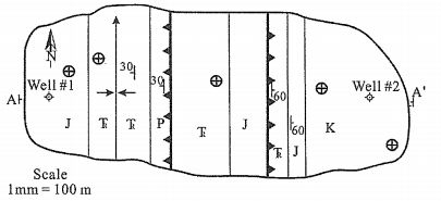
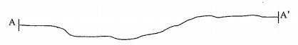
7. The following figure contains a geologic map and topographic profile. Two wells have been drilled in the area, as indicated on the map. Well number I encountered a thrust decollement at 1500 m. Well number 2 encountered the following units:
 Regional mapping indicates that the thickness of Cretaceous rocks is 700 m. Use the map, together with stratigraphic thicknesses from the well log and regional mapping, to construct a cross section on the topographic profile. Be sure to show the eroded layers above the level the present exposure. Determine and draw the type of fold present along AA' by using the topographic profile. (10 points)
 阿摩線上測驗
登入
阿摩線上測驗
登入