阿摩線上測驗
登入
首頁
>
研究所、轉學考(插大)◆自然地理學
>
110年 - 110 國立臺灣大學_碩士班招生考試_地理環境資源研究所甲組:自然地理學#100481
>
題組內容
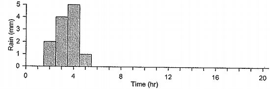
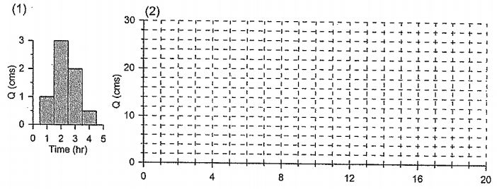
2.(15%)單位歷線為水文學常用的分析方法之一。已知某一集水區的單位歷線如圖(1)所示。
(1)(7.5%)請完成圖(2)(!請騰繪答案於作答卷)。
其他申論題
(2)遞減係數,由大到小的排列
#420613
(3)哪兩種土壤可能是相同的土壤
#420614
(4)說明控制初始入滲率的因素?
#420615
(5)說明控制穩定入滲率的因素?(每小題3分)
#420616
(2)(7.5%)請說明單位歷線的假設與使用限制。
#420618
3.(10%) Brunsden(1989)曾提出10條地形學定律,如下所示。請挑選其中2條為例,就自己的所知說明需要遵守或不遵守的理由? (1) The style and location of landform change is determined by the type, location and tate of tectonic movement. (2) Landforms are shaped by tectonic and denudation processes proceeding concurrently. (3) The lower boundary for landforn development is set by varying sea levcls. (4) For any given set of environmental conditions there will be a tendency to produce a set of characteristic landforms. (5) Landforms are contirually subject to perturbations. These impulses are episodic and compliex. (6) Within each tectono-climatic regime. landforns are produced by specific process events called formative events. (7) New landforms are produced when an event is reached on the frequency-magnitude scale of a given tectono- climatic regime and a geocatastrophe occurs. (8) When a perturbation exceeds the resistance if the system will react and relax toward a new stable state or characteristic form. (9) There is wide spatial variation in landform sensitivity to change. Hence landscape stability is diverse and complex. (10) The ability of a landscape to resist impulses of change tends to increase with time.
#420619
1.試以天然河川為基礎,完成下表(5分)(!請腾寫答案於作答卷)。
#420620
2.試提出如何明確、具體區分一條河的上、中、下游的指標或方法(5分)。
#420621
(1)(6%)試以圖文解釋 Water vapor-greenhouse gas feedback mechanism。
#420622
(2)(8%)下圖出自於IPCC AR5 報告中,請解釋Radiative Forcing 的定義,並請由能量收支的觀點,解釋"Albedo change due to land use"為何會呈現負值?
#420623
 阿摩線上測驗
登入
阿摩線上測驗
登入